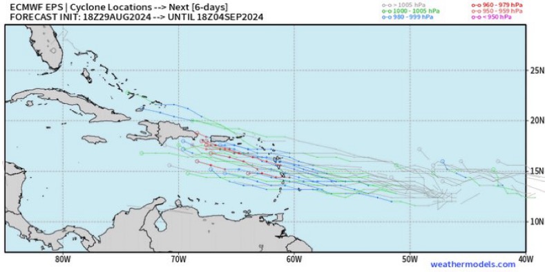
otowntiger wrote:Teban54 wrote:otowntiger wrote: Hasn’t this season proven beyond a shadow of a doubt that hurricanes need way more than just hot water? We’ve had boiling water all season long all across the the whole basin.
Hence why the tweet said
ceiling.
other factors work along with SST’s to determine the ceiling height.
This is literally not what ceiling means (or at least definitely not the intended meaning in Patel's tweet), unless you defined it as the peak intensity the storm will actually reach eventually, which is very uncommon in this context.
SSTs and their anomalies matter in providing us an
upper bound (best-case scenario for the storm, worst-case scenario for impacts) of how strong the storm
could potentially be. Of course, every storm needs to stay clear of shear and dry air, have the right structure, have enough time to intensify, etc. in order to realize these potentials. But if SSTs in the Caribbean and Gulf were 26°C, we can confidently say the storm will almost never intensify to a major hurricane, and thus,
wind impacts to land masses nearby will likely be limited.
This is certainly not the case here with widespread 30-32°C waters. Theoretically, waters in the Caribbean and Gulf now can support a sub-900 mb Cat 5. Of course, nobody is betting on that yet, even though it can technically happen. But more importantly,
warmer waters make the storm more likely to rapidly intensify as long as other factors cooperate. Under the same shear and humidity conditions, you may end up with a storm going from Cat 1 to Cat 4 over 30°C waters in the same time frame as another storm from Cat 1 to Cat 3 over 28°C waters. We've seen this way too often in recent years: take any of the Gulf landfalling majors in the last 7 years, or Lee last year in an El Nino. And the difference in impact between a Cat 4 and a Cat 3 can be significant.


