NATL: MELISSA - Models

Current storms and invests:

Moderators: hurricanetrack, S2k Moderators


The posts in this forum are NOT official forecasts and should not be used as such. They are just the opinion of the poster and may or may not be backed by sound meteorological data. They are NOT endorsed by any professional institution or STORM2K. For official information, please refer to products from the National Hurricane Center and National Weather Service.

Help Support Storm2K
Message
Author
User avatar
Blown Away
S2K Supporter
S2K Supporter
Posts: 10222
Joined: Wed May 26, 2004 6:17 am

Re: NATL: MELISSA - Models

#361 Postby Blown Away » Thu Oct 23, 2025 7:33 pm

aspen wrote:18z HWRF is by far the furthest south it’s ever been, showing landfalls along the southern coast of Jamaica as a Cat 4/5.

It’s like the HWRF and HAFS swapped forecast tracks this model cycle.


Big shift on HWRF, much slower.
0 likes   
Hurricane Eye Experience: David 79, Irene 99, Frances 04, Jeanne 04, Wilma 05… Hurricane Brush Experience: Andrew 92, Erin 95, Floyd 99, Matthew 16, Irma 17, Ian 22, Nicole 22…

User avatar
Blown Away
S2K Supporter
S2K Supporter
Posts: 10222
Joined: Wed May 26, 2004 6:17 am

Re: NATL: MELISSA - Models

#362 Postby Blown Away » Thu Oct 23, 2025 8:21 pm

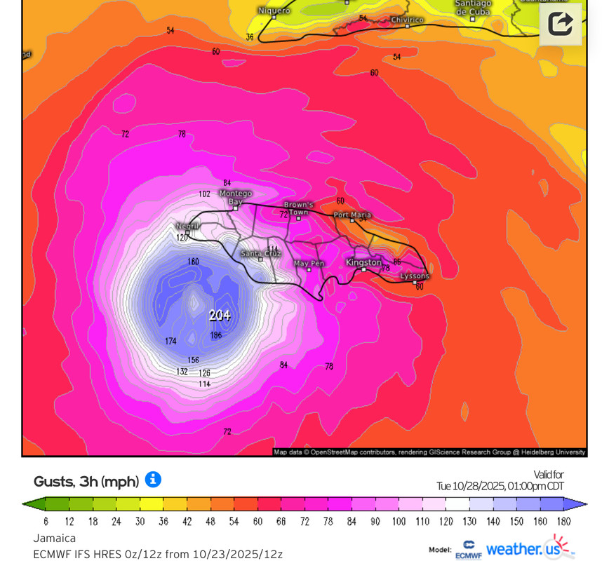
Image

Yikes, Euro 12z gust potential…
2 likes   
Hurricane Eye Experience: David 79, Irene 99, Frances 04, Jeanne 04, Wilma 05… Hurricane Brush Experience: Andrew 92, Erin 95, Floyd 99, Matthew 16, Irma 17, Ian 22, Nicole 22…

User avatar
Beef Stew
Category 2
Category 2
Posts: 535
Joined: Sat May 30, 2020 11:31 am
Location: South Florida

Re: NATL: MELISSA - Models

#363 Postby Beef Stew » Thu Oct 23, 2025 9:10 pm

If today's trend is to be believed, it's looking increasingly possible (which, given the amount of uncertainty with this storm, isn't saying much) that Melissa will either make landfall (or come incredibly close to making landfall) on Jamaica from the east as she initiates the westerly turn, as opposed to from the southwest following the westerly turn. Should this happen, her ceiling in terms of windspeed may be limited, but the flooding would be beyond catastrophic- Melissa would essentially be parked over the island for 2+ days.

Just to give an idea of the scale of destruction that could cause: it would actually probably be the better scenario if Melissa were to stay over water to the south of Jamaica, bomb into a category 5, and then pass through the island at C4/5 strength while heading northeast at pace...
3 likes   

Keldeo1997
Category 2
Category 2
Posts: 660
Joined: Fri Oct 11, 2019 11:35 pm

Re: NATL: MELISSA - Models

#364 Postby Keldeo1997 » Thu Oct 23, 2025 9:25 pm

1 likes   

User avatar
Hurricane2022
Category 5
Category 5
Posts: 1765
Joined: Tue Aug 23, 2022 11:38 pm
Location: Araçatuba, Brazil

Re: NATL: MELISSA - Models

#365 Postby Hurricane2022 » Thu Oct 23, 2025 9:26 pm

1 likes   
Sorry for the bad English sometimes...!
For reliable and detailed information for any meteorological phenomenon, please consult the National Hurricane Center, Joint Typhoon Warning Center , or your local Meteo Center.

--------

ECCE OMNIA NOVA FACIAM (Ap 21,5).

User avatar
chaser1
S2K Supporter
S2K Supporter
Posts: 5713
Age: 64
Joined: Sat Oct 15, 2005 5:59 pm
Location: Longwood, Fl

Re: NATL: MELISSA - Models

#366 Postby chaser1 » Thu Oct 23, 2025 10:00 pm

Problem with Tropical Tidbits updating?? I keep trying to check the model 500mb vorticity maps and the analysis time goes back to 10/21 0Z. Tried it with ICON and GFS
0 likes   
Andy D

(For official information, please refer to the NHC and NWS products.)

BobHarlem
Category 5
Category 5
Posts: 2527
Joined: Thu Oct 20, 2005 6:11 pm

Re: NATL: MELISSA - Models

#367 Postby BobHarlem » Thu Oct 23, 2025 11:06 pm

0z icon keeps it east of Jamaica and gets to a hurricane then just poofs south of Cuba.
0z GFS is actually east of the 18z, over haiti again. (shows a reform well east of the NHC current position also).
0z Canadian gets west of Jamaica to the south.

Models are so out to lunch on this one it must be 2025.
2 likes   

User avatar
kevin
Category 5
Category 5
Posts: 2793
Age: 27
Joined: Wed Aug 28, 2019 4:35 am

Re: NATL: MELISSA - Models

#368 Postby kevin » Fri Oct 24, 2025 12:12 am

Every time someone is like 'looks like it's shifting east, south of Jamaica can be ruled out' the next post is 'ensemble shifts west again, no chance this gets north of Jamaica' :lol:. Not blaming anyone, the models are really all over the place, I also have no clue what to think.
6 likes   

Keldeo1997
Category 2
Category 2
Posts: 660
Joined: Fri Oct 11, 2019 11:35 pm

Re: NATL: MELISSA - Models

#369 Postby Keldeo1997 » Fri Oct 24, 2025 1:19 am

Image

EURO with a curve ball shifting Way south and west
7 likes   

User avatar
kevin
Category 5
Category 5
Posts: 2793
Age: 27
Joined: Wed Aug 28, 2019 4:35 am

Re: NATL: MELISSA - Models

#370 Postby kevin » Fri Oct 24, 2025 4:21 am

06z ICON makes a big jump west and is the first run of the model showing a Jamaica landfall/impact. Whether its south/west shifts will stop here at the Jamaica consensus or will continue to the point of the 00z Euro is of course not possible to determine right now.

Image
0 likes   

User avatar
kevin
Category 5
Category 5
Posts: 2793
Age: 27
Joined: Wed Aug 28, 2019 4:35 am

Re: NATL: MELISSA - Models

#371 Postby kevin » Fri Oct 24, 2025 4:51 am

06z GFS also makes a big jump west, now in between Jamaica and Haiti and travelling NW. Finally it also doesn't show a Hispaniola landfall anymore. Trend of the last 5 runs:

Image
0 likes   

User avatar
kevin
Category 5
Category 5
Posts: 2793
Age: 27
Joined: Wed Aug 28, 2019 4:35 am

Re: NATL: MELISSA - Models

#372 Postby kevin » Fri Oct 24, 2025 5:17 am

06z GEFS also shifts SW with the mean now SW of Jamaica at +66hr. The GEFS mean will probably still strike Jamaica as Melissa curves north, but this is definitely more of a swing in the direction of the Euro in terms of track.

Image
Last edited by kevin on Fri Oct 24, 2025 5:19 am, edited 1 time in total.
0 likes   

User avatar
DESTRUCTION5
Category 5
Category 5
Posts: 4428
Age: 44
Joined: Wed Sep 03, 2003 11:25 am
Location: Stuart, FL

Re: NATL: MELISSA - Models

#373 Postby DESTRUCTION5 » Fri Oct 24, 2025 5:17 am

kevin wrote:06z GFS also makes a big jump west, now in between Jamaica and Haiti and travelling NW. Finally it also doesn't show a Hispaniola landfall anymore. Trend of the last 5 runs:

https://i.imgur.com/YUerEe6.gif


06 GFS pulled off the impossible missing all landfalls.
0 likes   
GATOR NATION IS E V E R Y W H E R E !

User avatar
Hypercane_Kyle
Category 5
Category 5
Posts: 3413
Joined: Sat Mar 07, 2015 7:58 pm
Location: Cape Canaveral, FL

Re: NATL: MELISSA - Models

#374 Postby Hypercane_Kyle » Fri Oct 24, 2025 5:49 am

HAFS-A is truly cataclysmic for Jamacia with a Cat 5 crawling along the coastline.

Honestly at this point "best" case scenario for all parties is if Melissa's inner core goes south of Jamacia and bombs out there. That way there's at least opportunity for it to weaken enroute to Cuba, where it'll also be faster.
1 likes   
My posts are my own personal opinion, defer to the National Hurricane Center (NHC) and other NOAA products for decision making during hurricane season.

User avatar
kevin
Category 5
Category 5
Posts: 2793
Age: 27
Joined: Wed Aug 28, 2019 4:35 am

Re: NATL: MELISSA - Models

#375 Postby kevin » Fri Oct 24, 2025 6:00 am

Well... 06z HAFS-B just loses Melissa, at least for the first 39 hours. At +39hr it's looking at a slightly interesting blob of convection at 69W. Maybe the more large-scale HAFS-B parent will later be able to give useful info.
0 likes   

User avatar
ronjon
Category 5
Category 5
Posts: 4878
Joined: Fri Aug 19, 2005 5:17 pm
Location: Hernando Beach, FL

Re: NATL: MELISSA - Models

#376 Postby ronjon » Fri Oct 24, 2025 6:02 am

With all the inconsistent modeling, it appears to me that the Euro operational has been the most consistent and that other models like the GFS are trending it's way. Still have to see the next few days but Melissa may have painfully exposed the GFS yet again as the less accurate simulation.
0 likes   

User avatar
kevin
Category 5
Category 5
Posts: 2793
Age: 27
Joined: Wed Aug 28, 2019 4:35 am

Re: NATL: MELISSA - Models

#377 Postby kevin » Fri Oct 24, 2025 6:02 am

At +42hr it's seems to become visible again on the western edge of the HAFS-B view as a meandering TS (while other models already have it nearing MH strength).

Image
0 likes   

User avatar
kevin
Category 5
Category 5
Posts: 2793
Age: 27
Joined: Wed Aug 28, 2019 4:35 am

Re: NATL: MELISSA - Models

#378 Postby kevin » Fri Oct 24, 2025 6:14 am

Potentially good news for Jamaica, 06z hurricane models show a big shift south. As in a full degree south of Jamaica. Let's see whether they also show Melissa missing Jamaica during the recurve.
1 likes   

User avatar
aspen
Category 5
Category 5
Posts: 8954
Joined: Sat Oct 12, 2019 7:10 pm
Location: Connecticut, USA

Re: NATL: MELISSA - Models

#379 Postby aspen » Fri Oct 24, 2025 6:17 am

Huge downtrend on the HAFS, especially the HAFS-A, which still has a sheared TS out to 51 hours.
0 likes   
Irene '11 Sandy '12 Hermine '16 5/15/2018 Derecho Fay '20 Isaias '20 Elsa '21 Henri '21 Ida '21

I am only a meteorology enthusiast who knows a decent amount about tropical cyclones. Look to the professional mets, the NHC, or your local weather office for the best information.

User avatar
aspen
Category 5
Category 5
Posts: 8954
Joined: Sat Oct 12, 2019 7:10 pm
Location: Connecticut, USA

Re: NATL: MELISSA - Models

#380 Postby aspen » Fri Oct 24, 2025 6:23 am

All hurricane models are now well south of Jamaica, with significantly reduced intensity estimates out to 48-60 hours compared to prior runs. The HMON is so far the strongest, eventually showing RI into a major SW of Jamaica.
1 likes   
Irene '11 Sandy '12 Hermine '16 5/15/2018 Derecho Fay '20 Isaias '20 Elsa '21 Henri '21 Ida '21

I am only a meteorology enthusiast who knows a decent amount about tropical cyclones. Look to the professional mets, the NHC, or your local weather office for the best information.


Return to “Active Storms/Invests - Atlantic/EastPAC/CentralPAC/MED”

Who is online

Users browsing this forum: al78 and 132 guests