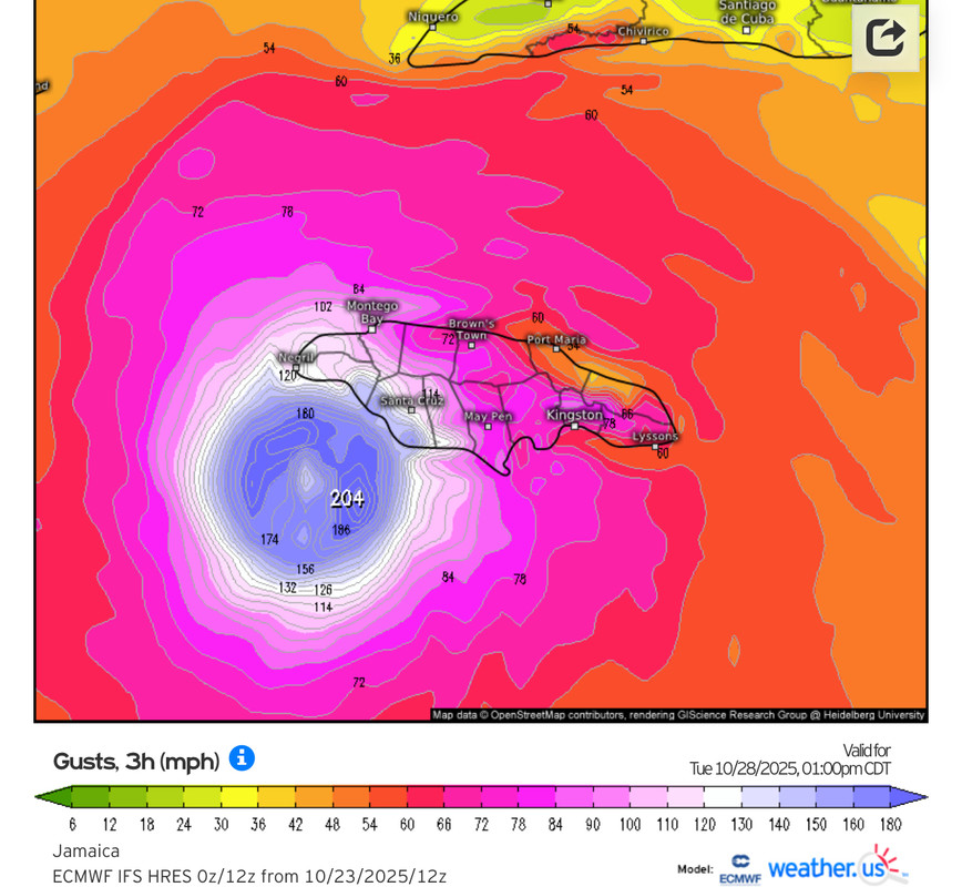
NATL: MELISSA - Models
Moderators: hurricanetrack, S2k Moderators

The posts in this forum are NOT official forecasts and should not be used as such. They are just the opinion of the poster and may or may not be backed by sound meteorological data. They are NOT endorsed by any professional institution or STORM2K. For official information, please refer to products from the National Hurricane Center and National Weather Service.
Re: NATL: MELISSA - Models
If this goes south of Jamaica like the Euro is showing, it will be a win for both Jamaica and the cat 5 enthusiasts.
5 likes
Igor 2010, Sandy 2012, Fay 2014, Gonzalo 2014, Joaquin 2015, Nicole 2016, Humberto 2019, Imelda 2025
I am only a tropical weather enthusiast. My predictions are not official and may or may not be backed by sound meteorological data. For official information, please refer to the NHC and NWS products.
Re: NATL: MELISSA - Models
06z HAFS-B still finds a way to wallop Jamaica with a Cat 5, despite its SW track shift. It starts recurving much sooner than the HAFS-A.
Since the HAFS-B completely loses the center of Melissa for the early part of its run, it’s impossible to tell if it correctly initialized around the new center location of 16.0N/75.1W like the HAFS-A.
1 likes
Irene '11 Sandy '12 Hermine '16 5/15/2018 Derecho Fay '20 Isaias '20 Elsa '21 Henri '21 Ida '21
I am only a meteorology enthusiast who knows a decent amount about tropical cyclones. Look to the professional mets, the NHC, or your local weather office for the best information.
Re: NATL: MELISSA - Models
Recon finding a weak center north of 16N, while most of the 00z models initialized about a half degree further south.
That is at zero hours and some models like the UKMET require a significant track slide SW to verify.
Pretty bad when AI can`t even forecast 6 hours out.
That is at zero hours and some models like the UKMET require a significant track slide SW to verify.
Pretty bad when AI can`t even forecast 6 hours out.
0 likes
Re: NATL: INVEST 98L - Models
zzzh wrote:https://i.imgur.com/2DzMl7G.png
There is still a huge split
Forecast is, it's south of Cuba, then it goes somewhere....
2 likes
I'm not a meteorologist, I'm an electronics engineer. While I can probably fix your toaster oven, you're not going to learn about storms from me!
New Mexico had no hurricanes. Then I moved to NC right before Fran.....
- Blown Away
- S2K Supporter

- Posts: 10222
- Joined: Wed May 26, 2004 6:17 am
Re: NATL: MELISSA - Models
Some big W shifts with the 06z HMON and HWRF.
0 likes
Hurricane Eye Experience: David 79, Irene 99, Frances 04, Jeanne 04, Wilma 05… Hurricane Brush Experience: Andrew 92, Erin 95, Floyd 99, Matthew 16, Irma 17, Ian 22, Nicole 22…
-
tolakram
- Admin

- Posts: 20124
- Age: 62
- Joined: Sun Aug 27, 2006 8:23 pm
- Location: Florence, KY (name is Mark)
Re: NATL: MELISSA - Models
We are closing in on when we see what model biases win. The GFS reformation from shear northerly solution vs a more consistent LLC that continues to move west. Levi did a good explanation of the GFS bias to always move the LLC toward a vigorous MLC. It's been years and I forget the storm but I still remember when the Euro had a hurricane into Texas while the GFS had a storm crossing Florida. GFS 'won' due to the reformation bias.
I use the terms win and lose loosely as a model bias will win when it wins, but it's not really a win IMO.
4 likes
M a r k
- - - - -
Join us in chat: Storm2K Chatroom Invite. Android and IOS apps also available.
The posts in this forum are NOT official forecasts and should not be used as such. Posts are NOT endorsed by any professional institution or STORM2K.org. For official information and forecasts, please refer to NHC and NWS products.
Re: NATL: MELISSA - Models
I have consistently given the CMC minimal "tropical cred" however it again has shifted back to its westerly outlier forecast track. I do believe that it my be overplaying the strength of the soon to shift east Gulf ridge but I do think that a more reliable potential track might well be a blend of the EURO and CMC. That would be even better yet for Jamaica AND Cat 5 enthusiasts!
1 likes
Andy D
(For official information, please refer to the NHC and NWS products.)
Re: NATL: MELISSA - Models
12z guidance shifts west again, but most of them still show a Jamaica landfall around +96hr.


0 likes
Re: NATL: MELISSA - Models
06z Euro goes south of Jamaica, but then still hits it as it travels north at the end of the run, +117hr & 935mb.


0 likes
- DorkyMcDorkface
- Category 4

- Posts: 960
- Age: 27
- Joined: Mon Sep 30, 2019 1:32 pm
- Location: Mid-Atlantic
Re: NATL: MELISSA - Models

4 likes
Please note the thougths expressed by this account are solely those of the user and are from a hobbyist perspective. For more comprehensive analysis, consult an actual professional meteorologist or meteorology agency.
Floyd 1999 | Isabel 2003 | Hanna 2008 | Irene 2011 | Sandy 2012 | Isaias 2020
Re: NATL: MELISSA - Models
Surprised nobody is talking about the UKMET run. Am I correct in thinking it was the most accurate last year?
0 likes
Re: NATL: MELISSA - Models
Canadian finally coming on board with the majority of the models showing the NE turn after Jamaica and over eastern Cuba.
0 likes
Re: NATL: MELISSA - Models
chaser1 wrote:I have consistently given the CMC minimal "tropical cred" however it again has shifted back to its westerly outlier forecast track. I do believe that it my be overplaying the strength of the soon to shift east Gulf ridge but I do think that a more reliable potential track might well be a blend of the EURO and CMC. That would be even better yet for Jamaica AND Cat 5 enthusiasts!
Except maybe the Cayman Islands and central Cuba.
0 likes
Re: NATL: MELISSA - Models
HAFS-A/B seem to initialize fairly well and both show Melissa going south of Jamaica through 60-72 hours.
HWRF is too far west and gets much closer to Jamaica’s southern coast by 39hrs out.
0 likes
Irene '11 Sandy '12 Hermine '16 5/15/2018 Derecho Fay '20 Isaias '20 Elsa '21 Henri '21 Ida '21
I am only a meteorology enthusiast who knows a decent amount about tropical cyclones. Look to the professional mets, the NHC, or your local weather office for the best information.
Re: NATL: MELISSA - Models
Interestingly, all hurricane models show an EWRC starting sometime on Monday. Both HAFS models have Melissa bottom out in the 910s as this occurs on Monday afternoon into evening, as it stalls south of the western tip of Jamaica.
I do not like where these runs are headed. Probably an intensifying system was an expanded wind field making a beeline for Jamaica.
1 likes
Irene '11 Sandy '12 Hermine '16 5/15/2018 Derecho Fay '20 Isaias '20 Elsa '21 Henri '21 Ida '21
I am only a meteorology enthusiast who knows a decent amount about tropical cyclones. Look to the professional mets, the NHC, or your local weather office for the best information.
Re: NATL: MELISSA - Models
caneseddy wrote:Canadian finally coming on board with the majority of the models showing the NE turn after Jamaica and over eastern Cuba.
Meanwhile, the UKMET continues to correct with a more E track and stronger. It now goes over C Cuba to Andros, still W of the other models. Its performance for Melissa has been terrible (F) due to all of those early runs staying weak and going into Nicaragua and the opposite of its stellar results for Imelda/Ian among others. It is such a hit or miss model!
2 likes
Personal Forecast Disclaimer:
The posts in this forum are NOT official forecasts and should not be used as such. They are just the opinion of the poster and may or may not be backed by sound meteorological data. They are NOT endorsed by any professional institution or storm2k.org. For official information, please refer to the NHC and NWS products.
Return to “Active Storms/Invests - Atlantic/EastPAC/CentralPAC/MED”
Who is online
Users browsing this forum: kevin, Yahoo [Bot] and 153 guests


