NATL: MELISSA - Aftermath - Discussion
Moderator: S2k Moderators

Re: NATL: MELISSA - Hurricane - Discussion
Both of the HAFS models peak this on Tuesday morning. Melissa is already stronger than what those models are showing tomorrow so who knows where the bottom is.
6 likes


Re: NATL: MELISSA - Hurricane - Discussion
Hurricane2022 wrote:Melissa continues to strengthen. And to the delight of all of us, the next recon penetration of Melissa's eye will be in only 8 hours.
Given the steep deepening trend on this flight & the fact that satellite estimates remain well above Melissa's observed intensity (T7.7 ADT, T7.5 subjective at time of writing), the NHC may be more willing to raise their 18z/21z intensity estimates during the gap. It seems clear at this point that Melissa "intends" to catch up to her appearance.
1 likes

Re: NATL: MELISSA - Hurricane - Discussion
Hurricane2022 wrote:Melissa continues to strengthen. And to the delight of all of us, the next recon penetration of Melissa's eye will be in only 8 hours.
I'll never understand why they send in two planes at the same time yet have 8 hour gaps between center fixes. 8 hours between flights is absurd in a situation like this.
3 likes
Re: NATL: MELISSA - Hurricane - Discussion
tulum07 wrote:With the current track, looks like Jamaica will avoid landfall. Next stop, Cuba instead.
unfortunately that's not going to happen, it's pretty much on the NHC track (since 5pm yesterday's).
2 likes
-
Keldeo1997
- Category 2

- Posts: 688
- Joined: Fri Oct 11, 2019 11:35 pm

Re: NATL: MELISSA - Hurricane - Discussion
Pelicane wrote:Both of the HAFS models peak this on Tuesday morning. Melissa is already stronger than what those models are showing tomorrow so who knows where the bottom is.
One caveat -- as I mentioned in the models thread:
Teban54 wrote:On the other hand, IIRC it's not uncommon for the intensities and timings of 1st and 2nd peaks on hurricane models to be "flipped". When Milton formed, the hurricane models generally forecasted its second peak to be stronger than the first. That didn't verify: the actual intensities were 895/155 for the first peak, 902/145 for the second.
4 likes
TC naming lists: retirements and intensity
Most aggressive Advisory #1's in North Atlantic (cr. kevin for starting the list)
Most aggressive Advisory #1's in North Atlantic (cr. kevin for starting the list)

Re: NATL: MELISSA - Hurricane - Discussion
Hurricane2022 wrote:Melissa continues to strengthen. And to the delight of all of us, the next recon penetration of Melissa's eye will be in only 8 hours.
I don’t get why they scheduled such long gaps in coverage for most days. Yesterday’s schedule with AF taking off just as NOAA left Melissa was a lot better and reduced the gap in coverage. 8 hours is too much for a system within 24 hours of landfall; it should be getting as little gaps as possible.
6 likes
Irene '11 Sandy '12 Hermine '16 5/15/2018 Derecho Fay '20 Isaias '20 Elsa '21 Henri '21 Ida '21
I am only a meteorology enthusiast who knows a decent amount about tropical cyclones. Look to the professional mets, the NHC, or your local weather office for the best information.
I am only a meteorology enthusiast who knows a decent amount about tropical cyclones. Look to the professional mets, the NHC, or your local weather office for the best information.
-
mrbagyo

- Category 5

- Posts: 3998
- Age: 33
- Joined: Thu Apr 12, 2012 9:18 am
- Location: 14.13N 120.98E
- Contact:
Re: NATL: MELISSA - Hurricane - Discussion
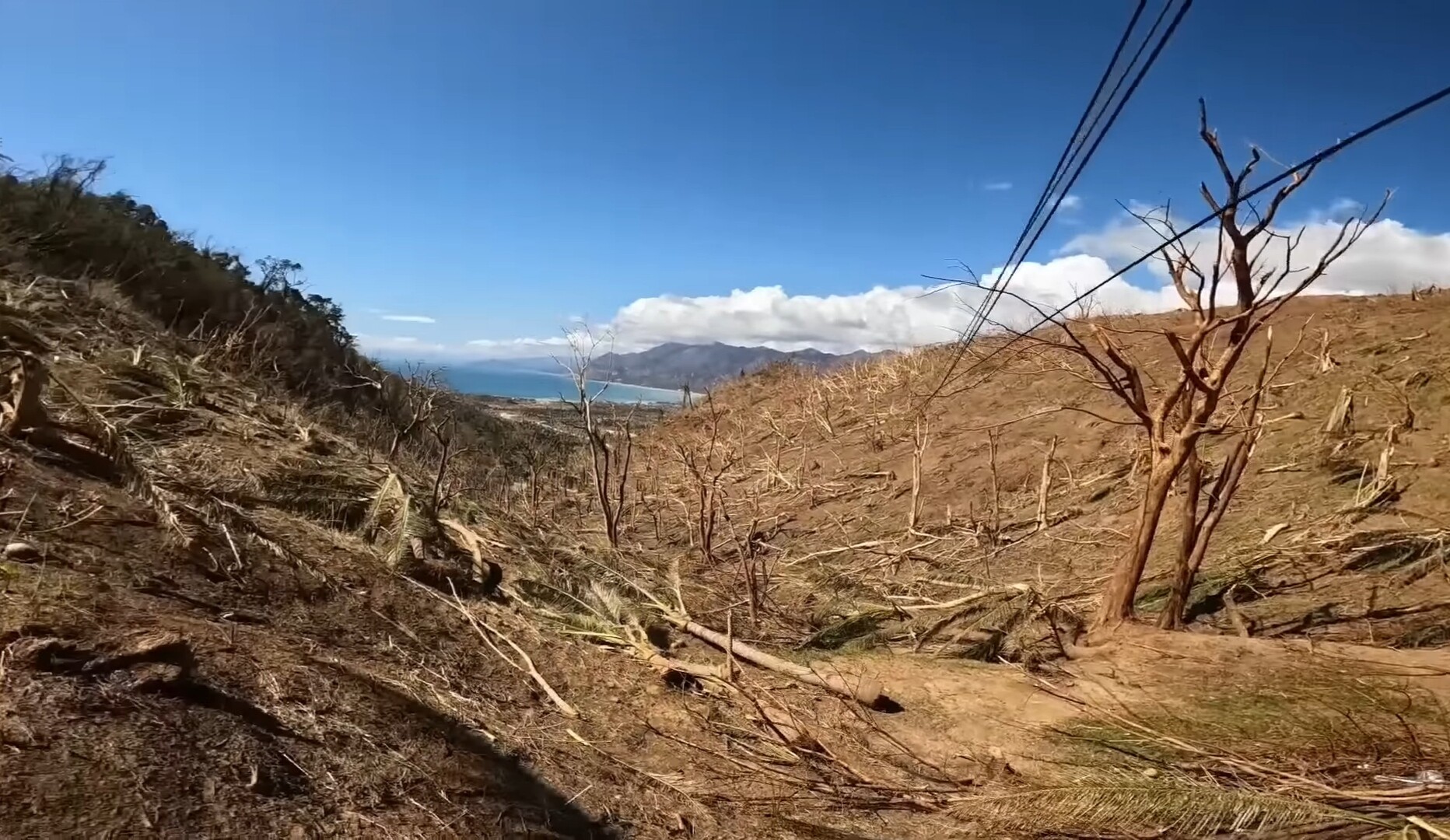
Travorum wrote:TallyTracker wrote:This is going to be like a 50-mile wide tornado where it makes landfall. I’d be looking for a reinforced concrete building or underground basement (outside a flood zone). I’m concerned that their building codes no matter how much they may have improved after Gilbert are going to be no match for a storm of this caliber. Praying for the folks there to be safe.
I'm really concerned about Melissa potentially making landfall near Treasure Beach. There are populated areas immediately east of there that are on cliffs 400m tall right near the coast that would be in the right front quadrant eyewall, and we saw from the dropsondes earlier what the winds look like 400m up.
It would look similar to this (elevated part of Dinadiawan, Aurora in the aftermath of Typhoon Manyi last year - this was an absolutely lush green jungle before the typhoon that you cant even see the coast due to vegetation)
3 likes
The posts in this forum are NOT official forecast and should not be used as such. They are just the opinion of the poster and may or may not be backed by sound meteorological data. They are NOT endorsed by any professional institution or storm2k.org. For official information, please refer to RSMC, NHC and NWS products.
-
Hurricane Mike
- Category 2
- Posts: 675
- Joined: Tue Apr 10, 2018 7:44 am
Re: NATL: MELISSA - Hurricane - Discussion
12pm Video Update
https://www.youtube.com/watch?v=IgD5Qu4xXkM
https://www.youtube.com/watch?v=IgD5Qu4xXkM
0 likes
-
Hurricane2022

- Category 5
- Posts: 2093
- Joined: Tue Aug 23, 2022 11:38 pm
- Location: Araçatuba, Brazil
Re: NATL: MELISSA - Hurricane - Discussion
5 likes
Sorry for the bad English sometimes...!
For reliable and detailed information for any meteorological phenomenon, please consult the National Hurricane Center, Joint Typhoon Warning Center , or your local Meteo Center.
--------
ECCE OMNIA NOVA FACIAM (Ap 21,5).
For reliable and detailed information for any meteorological phenomenon, please consult the National Hurricane Center, Joint Typhoon Warning Center , or your local Meteo Center.
--------
ECCE OMNIA NOVA FACIAM (Ap 21,5).


Re: NATL: MELISSA - Hurricane - Discussion
tulum07 wrote:With the current track, looks like Jamaica will avoid landfall. Next stop, Cuba instead.
Nope. On its current track, it would probably hit Belize...... in about 2-weeks
3 likes
Andy D
(For official information, please refer to the NHC and NWS products.)
(For official information, please refer to the NHC and NWS products.)
-
TallyTracker
- Category 2
- Posts: 787
- Joined: Thu Oct 11, 2018 2:46 pm
Re: NATL: MELISSA - Hurricane - Discussion
aspen wrote:Hurricane2022 wrote:Melissa continues to strengthen. And to the delight of all of us, the next recon penetration of Melissa's eye will be in only 8 hours.
I don’t get why they scheduled such long gaps in coverage for most days. Yesterday’s schedule with AF taking off just as NOAA left Melissa was a lot better and reduced the gap in coverage. 8 hours is too much for a system within 24 hours of landfall; it should be getting as little gaps as possible.
I have to remind myself not to tear my hair out in frustration in moments like this. Otherwise I’d be bald by Thanksgiving every year and that would be some frightening pictures.
3 likes
Fran '96, Georges '98, Gordon '00, Gabrielle '01, Charley '04, Frances '04, Jeanne '04, Barry '07, Fay '08, Debby '12, Matthew '16, Emily '17, Irma '17, Michael ‘18, Elsa ‘21, Fred ‘21, Mindy ‘21, Nicole ‘22, Idalia ‘23, Debby ‘24, Helene ‘24
-
rwfromkansas
- Category 5
- Posts: 3050
- Joined: Sat Aug 27, 2005 12:47 am
- Location: North Fort Worth
Re: NATL: MELISSA - Hurricane - Discussion
I don't follow the tropics much, but this one is a monster. What are the chances of it clipping the far SW side of the island? It seems to still be mostly going west. No real north turn yet, and each advisory just "moves" the turn just a little bit west. Much further west and it will be wrong again...
0 likes

Re: NATL: MELISSA - Hurricane - Discussion
Given the current plane took off from Curacao, could we get one more pass in on it's way back south? Or will it just land wherever is closest to it's current position?
0 likes

Re: NATL: MELISSA - Hurricane - Discussion
Hurricane2022 wrote:Melissa continues to strengthen. And to the delight of all of us, the next recon penetration of Melissa's eye will be in only 8 hours.
The current flight has a 17:30z fix requirement, so they're good for another pass. The next fix requirement is 23:30z. That's still a 6 hour gap but not quite as bad.
5 likes
Kendall -> SLO -> PBC
Memorable Storms: Katrina (for its Florida landfall...) Wilma Matthew Irma
Memorable Storms: Katrina (for its Florida landfall...) Wilma Matthew Irma
-
mrbagyo
- Category 5
- Posts: 3998
- Age: 33
- Joined: Thu Apr 12, 2012 9:18 am
- Location: 14.13N 120.98E
- Contact:
Re: NATL: MELISSA - Hurricane - Discussion
michelinj wrote:Given the current plane took off from Curacao, could we get one more pass in on it's way back south? Or will it just land wherever is closest to it's current position?
looks like the AF plane made a turn inside the eye and went north then west. Might go for one last NW-SE pass before heading home to Curacao
1 likes
The posts in this forum are NOT official forecast and should not be used as such. They are just the opinion of the poster and may or may not be backed by sound meteorological data. They are NOT endorsed by any professional institution or storm2k.org. For official information, please refer to RSMC, NHC and NWS products.

Re: NATL: MELISSA - Hurricane - Discussion
Feedback some the recon team itself seems to indicate that an eyewall merger already took place this morning and that the current structure of Melissa shows no indication of a new EWRC.
Melissa will likely continue intensifying for the time being at its current rate of 2 - 3 mb/hr until an EWRC starts. With about 7 hours until the next center pass this means Melissa could reach 884 - 891 mb within that time span which is possible with the current MPI and definitely supported by its satellite appearance. The main question will be whether Melissa can hold off another EWRC for another 7 hours and whether it'll be a race against the clock. I remember a similar case with Milton with people thinking recon missed its peak due to an EWRC only for the place to measure a sub-900mb pressure. One hour later it was already at 'only' 904 mb though due to the ongoing EWRC so it can be a range against the clock.
Melissa will likely continue intensifying for the time being at its current rate of 2 - 3 mb/hr until an EWRC starts. With about 7 hours until the next center pass this means Melissa could reach 884 - 891 mb within that time span which is possible with the current MPI and definitely supported by its satellite appearance. The main question will be whether Melissa can hold off another EWRC for another 7 hours and whether it'll be a race against the clock. I remember a similar case with Milton with people thinking recon missed its peak due to an EWRC only for the place to measure a sub-900mb pressure. One hour later it was already at 'only' 904 mb though due to the ongoing EWRC so it can be a range against the clock.
6 likes

Re: NATL: MELISSA - Hurricane - Discussion
Based on recon, Melissa is already as strong or stronger than Katrina at her peak, and she still has excellent conditions over the next 18 to 24 hours to strengthen even more. The only thing that can stop her now is an eyewall replacement cycle.
2 likes
-
Iceresistance

- Category 5
- Posts: 9608
- Age: 22
- Joined: Sat Oct 10, 2020 9:45 am
- Location: Tecumseh, OK/Norman, OK
Re: NATL: MELISSA - Hurricane - Discussion
kevin wrote:Feedback some the recon team itself seems to indicate that an eyewall merger already took place this morning and that the current structure of Melissa shows no indication of a new EWRC.
Melissa will likely continue intensifying for the time being at its current rate of 2 - 3 mb/hr until an EWRC starts. With about 7 hours until the next center pass this means Melissa could reach 884 - 891 mb within that time span which is possible with the current MPI and definitely supported by its satellite appearance. The main question will be whether Melissa can hold off another EWRC for another 7 hours and whether it'll be a race against the clock. I remember a similar case with Milton with people thinking recon missed its peak due to an EWRC only for the place to measure a sub-900mb pressure. One hour later it was already at 'only' 904 mb though due to the ongoing EWRC so it can be a range against the clock.
Andy Hazelton said there's just enough shear to prevent an outer eyewall from even forming
https://x.com/AndyHazelton/status/1982843734564950258
6 likes
Bill 2015 & Beta 2020
Winter 2020-2021
All observations are in Tecumseh, OK unless otherwise noted.
Winter posts are focused mainly for Oklahoma & Texas.
Take any of my forecasts with a grain of salt, refer to the NWS, SPC, and NHC for official information
Never say Never with weather! Because ANYTHING is possible!
Winter 2020-2021
All observations are in Tecumseh, OK unless otherwise noted.
Winter posts are focused mainly for Oklahoma & Texas.
Take any of my forecasts with a grain of salt, refer to the NWS, SPC, and NHC for official information
Never say Never with weather! Because ANYTHING is possible!
Who is online
Users browsing this forum: No registered users and 56 guests