No double wind max
Moderator: S2k Moderators

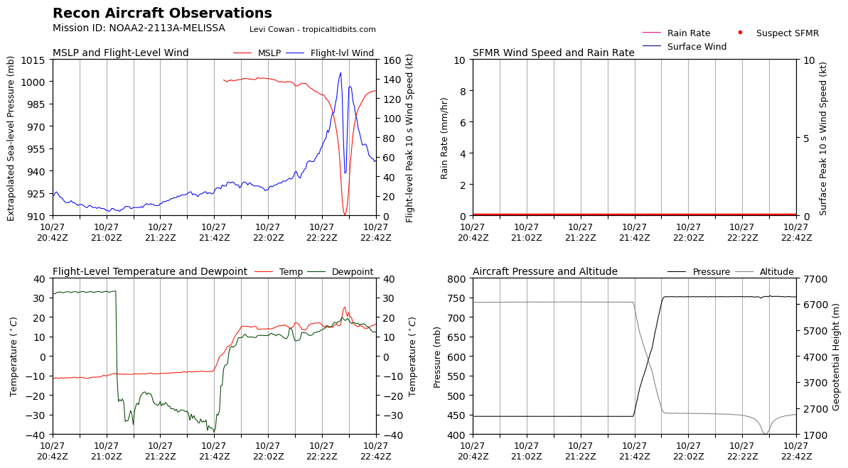
michelinj wrote:Latest eye drop showing 114kts at the surface? That feels too low unless I’m missing something. She’s definitely weakened a touch but that seems a little extreme
Edit: Another with 99kts so definitely something not quite right in that eyewall


kronotsky wrote:michelinj wrote:Latest eye drop showing 114kts at the surface? That feels too low unless I’m missing something. She’s definitely weakened a touch but that seems a little extreme
Edit: Another with 99kts so definitely something not quite right in that eyewall
Pressure from both sondes in the 950s at the surface – unless we think that Melissa is a 940.mb storm, it's safe to assume that those drops missed the eyewall.

hipshot wrote:kronotsky wrote:michelinj wrote:Latest eye drop showing 114kts at the surface? That feels too low unless I’m missing something. She’s definitely weakened a touch but that seems a little extreme
Edit: Another with 99kts so definitely something not quite right in that eyewall
Pressure from both sondes in the 950s at the surface – unless we think that Melissa is a 940.mb storm, it's safe to assume that those drops missed the eyewall.
When they drop those sondes inside the eye, how do we know where they actually windup. I guess they have a means to transmit their
position but as strong as those winds are, good luck!
Hypercane_Kyle wrote:CDO cooling again. A new deepening phase might be about to begin.

Beef Stew wrote:Data from that last pass seems odd all around. While I don’t doubt she’s weakened some since earlier (I personally think she may have peaked, at least initially, approximately ~2 hours after the AF plane left), I’m waiting for another pass before I’m sold on this much of a reduction for FL winds.
Hypercane_Kyle wrote:This is definitely one of the more p*ssed off looking hurricanes I've seen in the Atlantic.
https://i.imgur.com/JFxYQC8.png
kronotsky wrote:michelinj wrote:Latest eye drop showing 114kts at the surface? That feels too low unless I’m missing something. She’s definitely weakened a touch but that seems a little extreme
Edit: Another with 99kts so definitely something not quite right in that eyewall
Pressure from both sondes in the 950s at the surface – unless we think that Melissa is a 940.mb storm, it's safe to assume that those drops missed the eyewall.


cheezyWXguy wrote:Beef Stew wrote:Data from that last pass seems odd all around. While I don’t doubt she’s weakened some since earlier (I personally think she may have peaked, at least initially, approximately ~2 hours after the AF plane left), I’m waiting for another pass before I’m sold on this much of a reduction for FL winds.
Agreed, I think the FL measurements seem plausible but these dropsondes all seem…weird? 45% RH on drop 2 in the cdo? No T/Td spread in the eye drop? Odd…
eastcoastFL wrote:Still a very compact wind field and a very powerful tiny storm overall.


ScottNAtlanta wrote:Looking at the WV loop you can see the trough coming to get it. The turn should happen very soon
https://i.imgur.com/X9CGtX8.gif

Users browsing this forum: No registered users and 67 guests


