NATL: MELISSA - Hurricane - Discussion

Current storms and invests:

Moderators: hurricanetrack, S2k Moderators


The posts in this forum are NOT official forecasts and should not be used as such. They are just the opinion of the poster and may or may not be backed by sound meteorological data. They are NOT endorsed by any professional institution or STORM2K. For official information, please refer to products from the National Hurricane Center and National Weather Service.

Help Support Storm2K
Message
Author
michelinj
Tropical Depression
Tropical Depression
Posts: 67
Joined: Mon Aug 06, 2018 4:59 pm

Re: NATL: MELISSA - Hurricane - Discussion

#1761 Postby michelinj » Mon Oct 27, 2025 6:00 pm

kronotsky wrote:
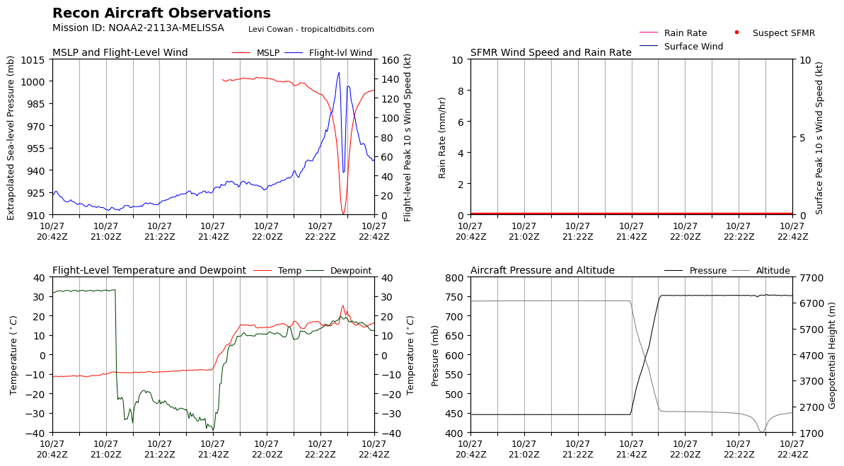
michelinj wrote:Latest eye drop showing 114kts at the surface? That feels too low unless I’m missing something. She’s definitely weakened a touch but that seems a little extreme

Edit: Another with 99kts so definitely something not quite right in that eyewall

Pressure from both sondes in the 950s at the surface – unless we think that Melissa is a 940.mb storm, it's safe to assume that those drops missed the eyewall.


That’s true, I still think the winds have eased just a little, would be consistent with the FL winds, pressure readings and IR over the last couple hours
1 likes   

User avatar
ScottNAtlanta
Category 5
Category 5
Posts: 2527
Joined: Sat May 25, 2013 3:11 pm
Location: Atlanta, GA

Re: NATL: MELISSA - Hurricane - Discussion

#1762 Postby ScottNAtlanta » Mon Oct 27, 2025 6:00 pm

Looking at the WV loop you can see the trough coming to get it. The turn should happen very soon
Image
5 likes   
The posts in this forum are NOT official forecast and should not be used as such. They are just the opinion of the poster and may or may not be backed by sound meteorological data. They are NOT endorsed by any professional institution or storm2k.org. For official information, please refer to the NHC and NWS products.

User avatar
eastcoastFL
Category 5
Category 5
Posts: 3990
Age: 43
Joined: Thu Apr 12, 2007 12:29 pm
Location: Palm City, FL

Re: NATL: MELISSA - Hurricane - Discussion

#1763 Postby eastcoastFL » Mon Oct 27, 2025 6:00 pm

Still a very compact wind field and a very powerful tiny storm overall.
0 likes   
Personal Forecast Disclaimer:
The posts in this forum are NOT official forecast and should not be used as such. They are just the opinion of the poster and may or may not be backed by sound meteorological data. They are NOT endorsed by any professional institution or storm2k.org. For official information, please refer to the NHC and NWS products.

User avatar
Beef Stew
Category 2
Category 2
Posts: 590
Joined: Sat May 30, 2020 11:31 am
Location: South Florida

Re: NATL: MELISSA - Hurricane - Discussion

#1764 Postby Beef Stew » Mon Oct 27, 2025 6:01 pm

cheezyWXguy wrote:
Beef Stew wrote:Data from that last pass seems odd all around. While I don’t doubt she’s weakened some since earlier (I personally think she may have peaked, at least initially, approximately ~2 hours after the AF plane left), I’m waiting for another pass before I’m sold on this much of a reduction for FL winds.

Agreed, I think the FL measurements seem plausible but these dropsondes all seem…weird? 45% RH on drop 2 in the cdo? No T/Td spread in the eye drop? Odd…


Yeah, very odd. Odd enough that I don’t think we can make anything of them until we have another set of drops to compare them to.
3 likes   

User avatar
Beef Stew
Category 2
Category 2
Posts: 590
Joined: Sat May 30, 2020 11:31 am
Location: South Florida

Re: NATL: MELISSA - Hurricane - Discussion

#1765 Postby Beef Stew » Mon Oct 27, 2025 6:04 pm

eastcoastFL wrote:Still a very compact wind field and a very powerful tiny storm overall.


She’s a Caribbean Milton.
3 likes   

User avatar
Hurricane2022
Category 5
Category 5
Posts: 1880
Joined: Tue Aug 23, 2022 11:38 pm
Location: Araçatuba, Brazil

Re: NATL: MELISSA - Hurricane - Discussion

#1766 Postby Hurricane2022 » Mon Oct 27, 2025 6:04 pm

It's happening again. Let's see how ADT (over)reacts to it :P
Image
5 likes   
Sorry for the bad English sometimes...!
For reliable and detailed information for any meteorological phenomenon, please consult the National Hurricane Center, Joint Typhoon Warning Center , or your local Meteo Center.

--------

ECCE OMNIA NOVA FACIAM (Ap 21,5).

SteveM
Tropical Depression
Tropical Depression
Posts: 79
Joined: Wed Jul 22, 2020 8:21 am

Re: NATL: MELISSA - Hurricane - Discussion

#1767 Postby SteveM » Mon Oct 27, 2025 6:06 pm

ScottNAtlanta wrote:Looking at the WV loop you can see the trough coming to get it. The turn should happen very soon
https://i.imgur.com/X9CGtX8.gif


Yes, it looks like some movement to the east, a northerly component might be about to be introduced too.
0 likes   

BobHarlem
Category 5
Category 5
Posts: 2566
Joined: Thu Oct 20, 2005 6:11 pm

Re: NATL: MELISSA - Hurricane - Discussion

#1768 Postby BobHarlem » Mon Oct 27, 2025 6:07 pm

Diurnal pink donut time again (Dvorak frosting). Cyclonic loop likely done, nne motion to begin soonish.
Image
9 likes   

crimi481
Category 2
Category 2
Posts: 608
Joined: Thu Sep 09, 2004 4:47 pm

Re: NATL: MELISSA - Hurricane - Discussion

#1769 Postby crimi481 » Mon Oct 27, 2025 6:14 pm

S.W. wobbles. Melissa créating own environment
0 likes   

zzzh
Category 5
Category 5
Posts: 1018
Joined: Thu Sep 02, 2021 1:13 pm

Re: NATL: MELISSA - Hurricane - Discussion

#1770 Postby zzzh » Mon Oct 27, 2025 6:18 pm

Eye temp continues to drop. It's been dropping since 18z.
0 likes   

zzzh
Category 5
Category 5
Posts: 1018
Joined: Thu Sep 02, 2021 1:13 pm

Re: NATL: MELISSA - Hurricane - Discussion

#1771 Postby zzzh » Mon Oct 27, 2025 6:21 pm

D. 912 mb
E. 165 deg 27 kt
F. CLOSED
G. C10
2 likes   

User avatar
Hurricane2022
Category 5
Category 5
Posts: 1880
Joined: Tue Aug 23, 2022 11:38 pm
Location: Araçatuba, Brazil

Re: NATL: MELISSA - Hurricane - Discussion

#1772 Postby Hurricane2022 » Mon Oct 27, 2025 6:23 pm

2 likes   
Sorry for the bad English sometimes...!
For reliable and detailed information for any meteorological phenomenon, please consult the National Hurricane Center, Joint Typhoon Warning Center , or your local Meteo Center.

--------

ECCE OMNIA NOVA FACIAM (Ap 21,5).

User avatar
storm_in_a_teacup
Category 1
Category 1
Posts: 484
Age: 33
Joined: Wed Aug 16, 2017 5:01 pm
Location: Huntsville, Alabama (originally from Houston)
Contact:

Re: NATL: MELISSA - Hurricane - Discussion

#1773 Postby storm_in_a_teacup » Mon Oct 27, 2025 6:32 pm

Beef Stew wrote:
eastcoastFL wrote:Still a very compact wind field and a very powerful tiny storm overall.


She’s a Caribbean Milton.


The width of her eye is similar to what I remember reading about the size of the Labor Day hurricane’s eye. Wonder how they compare size-wise
2 likes   
I know I can't straddle the atmosphere...just a tiny storm in your teacup, girl.

User avatar
cheezyWXguy
Category 5
Category 5
Posts: 6220
Joined: Mon Feb 13, 2006 12:29 am
Location: Dallas, TX

Re: NATL: MELISSA - Hurricane - Discussion

#1774 Postby cheezyWXguy » Mon Oct 27, 2025 6:33 pm

At first I thought the slight weakening might be due to another meld ongoing, but I’m not seeing any evidence of that. So now I’m wondering if it might be due to the increasing influence from the trough to the west trying to put a hard stop on its westward progress. I do recall the hafs earlier showing some slight weakening around this time, followed by a rebound after northward movement commenced and the storm motion aligns with the new mean flow. I’d be very happy if no rebound did occur, but I am curious if this is what we are seeing.
2 likes   

User avatar
WaveBreaking
Category 2
Category 2
Posts: 691
Joined: Sun Jun 30, 2024 11:33 am
Location: US

Re: NATL: MELISSA - Hurricane - Discussion

#1775 Postby WaveBreaking » Mon Oct 27, 2025 6:35 pm

Now almost completely stationary on meso.

Image
5 likes   
I am NOT a professional meteorologist, so take all of my posts with a grain of salt. My opinions are mine and mine alone.

michelinj
Tropical Depression
Tropical Depression
Posts: 67
Joined: Mon Aug 06, 2018 4:59 pm

Re: NATL: MELISSA - Hurricane - Discussion

#1776 Postby michelinj » Mon Oct 27, 2025 6:37 pm

cheezyWXguy wrote:At first I thought the slight weakening might be due to another meld ongoing, but I’m not seeing any evidence of that. So now I’m wondering if it might be due to the increasing influence from the trough to the west trying to put a hard stop on its westward progress. I do recall the hafs earlier showing some slight weakening around this time, followed by a rebound after northward movement commenced and the storm motion aligns with the new mean flow. I’d be very happy if no rebound did occur, but I am curious if this is what we are seeing.

That’s an interesting theory, could very well be right. The HAFS and other hi-res models are capable of picking out such fine details, remarkably. Let’s see!
0 likes   

User avatar
aspen
Category 5
Category 5
Posts: 9011
Joined: Sat Oct 12, 2019 7:10 pm
Location: Connecticut, USA

Re: NATL: MELISSA - Hurricane - Discussion

#1777 Postby aspen » Mon Oct 27, 2025 6:43 pm

cheezyWXguy wrote:At first I thought the slight weakening might be due to another meld ongoing, but I’m not seeing any evidence of that. So now I’m wondering if it might be due to the increasing influence from the trough to the west trying to put a hard stop on its westward progress. I do recall the hafs earlier showing some slight weakening around this time, followed by a rebound after northward movement commenced and the storm motion aligns with the new mean flow. I’d be very happy if no rebound did occur, but I am curious if this is what we are seeing.

I was thinking the same thing about the trough, although the slight weakening on the HAFS runs also seemed to be due to an eyewall meld.
0 likes   
Irene '11 Sandy '12 Hermine '16 5/15/2018 Derecho Fay '20 Isaias '20 Elsa '21 Henri '21 Ida '21

I am only a meteorology enthusiast who knows a decent amount about tropical cyclones. Look to the professional mets, the NHC, or your local weather office for the best information.

User avatar
Hurricane2022
Category 5
Category 5
Posts: 1880
Joined: Tue Aug 23, 2022 11:38 pm
Location: Araçatuba, Brazil

Re: NATL: MELISSA - Hurricane - Discussion

#1778 Postby Hurricane2022 » Mon Oct 27, 2025 6:43 pm

:cold: Image
4 likes   
Sorry for the bad English sometimes...!
For reliable and detailed information for any meteorological phenomenon, please consult the National Hurricane Center, Joint Typhoon Warning Center , or your local Meteo Center.

--------

ECCE OMNIA NOVA FACIAM (Ap 21,5).

User avatar
Zonacane
Category 1
Category 1
Posts: 404
Joined: Tue Aug 03, 2021 2:23 pm

Re: NATL: MELISSA - Hurricane - Discussion

#1779 Postby Zonacane » Mon Oct 27, 2025 6:44 pm

I think everybody is overreacting to a steady state storm
4 likes   

User avatar
Teban54
Category 5
Category 5
Posts: 3685
Joined: Sat May 19, 2018 1:19 pm

Re: NATL: MELISSA - Hurricane - Discussion

#1780 Postby Teban54 » Mon Oct 27, 2025 6:45 pm

Zonacane wrote:I think everybody is overreacting to a steady state storm

I would agree with you if not for the pretty significant drop in FL winds from the last pass, though. (I know that I could eat crow at any minute with the next pass on the way.)
3 likes   


Return to “Active Storms/Invests - Atlantic/EastPAC/CentralPAC/MED”

Who is online

Users browsing this forum: Beef Stew, dukeblue219, Kazmit and 130 guests